White Pine Blister Rust (WPBR)

Limber pine tree on a rocky outcrop in Rocky Mountain National Park.
The Rocky Mountain Region is being severely impacted by multiple forest health issues. Though the mountain pine beetle epidemic is waning, climate change continues to cause an escalation of stressful environmental conditions, and other pests and pathogens are gaining momentum. This region is home to three of North America’s high elevation white pines and their unique ecosystems are under threat; whitebark pine, Rocky Mountain bristlecone pine and limber pine are all susceptible to the non-native pathogen, Cronartium ribicola, which causes the lethal disease White Pine Blister Rust (WPBR). WPBR was introduced to North America in the early 1900s and has spread throughout much of the Rocky Mountain Region. The fungus affects trees of all ages and sizes and all North American white pines are susceptible. WPBR infects pine hosts when spores enter through the needle. The fungus grows down the needle and into the bark forming a canker which eventually girdles and kills the tree.

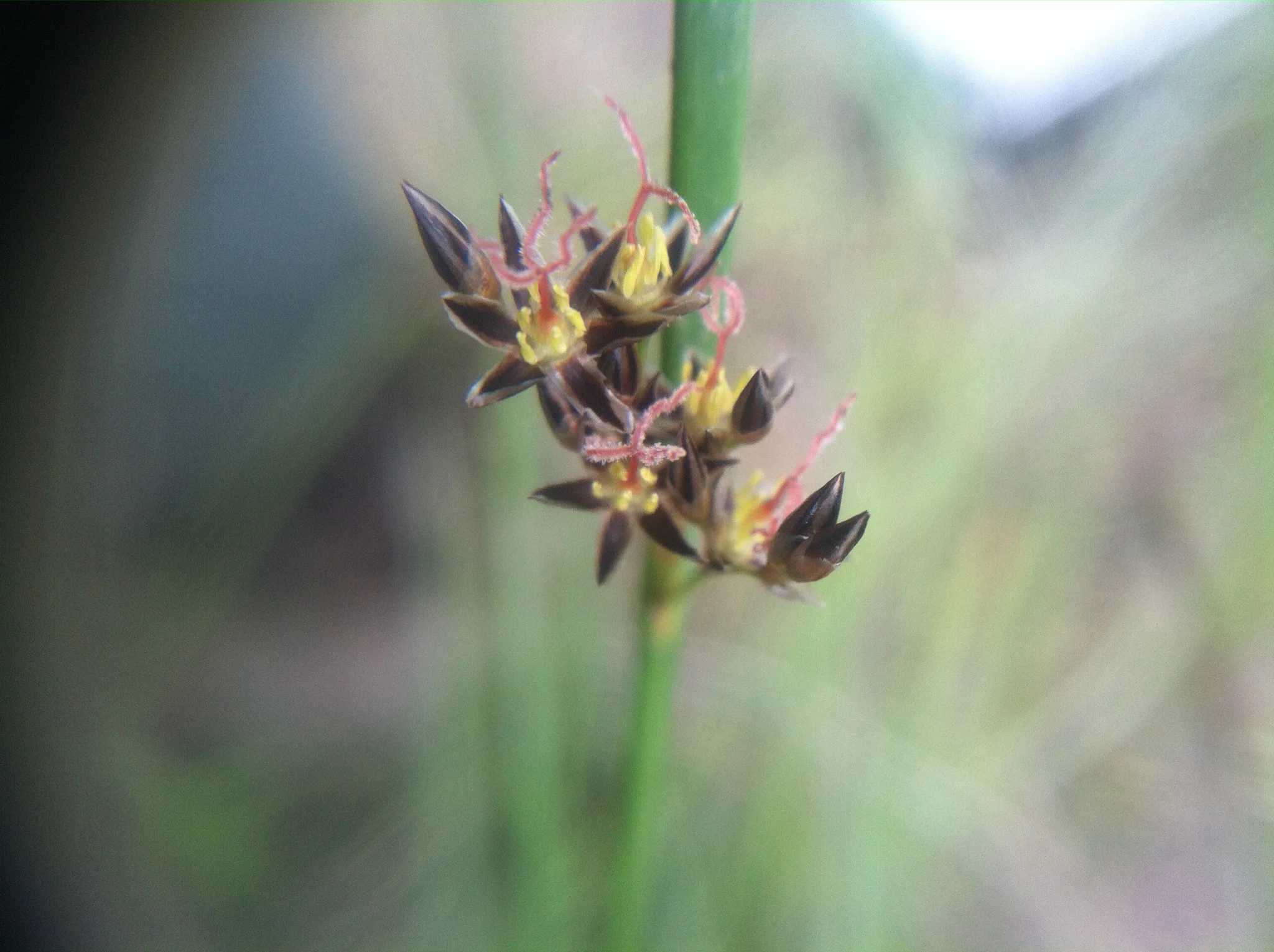
White pine blister rust produces orange, spore-filled blisters on the branches and main stem of the tree that burst allowing the spores to travel hundreds of miles.
Though WPBR is an invasive pathogen, genetic disease resistance has been found in all host species including limber pine. Limber pine is an incredibly resilient member of the white pines with a distribution ranging from New Mexico to Alberta, Canada. The needles are a beautiful light green with a slight blue tinge, and only the last few years of needle growth are retained on the branches giving the tree a distinctive profile easily identifiable in the wild. Limber pine is a keystone species functioning to maintain soil stability and ecosystem structure as well as provide habitat and food for wildlife. Living up to 1500 years, they are uniquely adapted to grow on exposed sites where high winds and low temperatures make it unsuitable for other tree species. In northern Colorado, Wyoming, and Southeastern Montana 73% of limber pines stands have been invaded by WPBR, and without intervention, the population of limber pine will continue to decline severely.
A considerable amount of the current research headed by Anna Schoettle at the Rocky Mountain Research Station focuses on limber pine and developing a proactive strategy to ensure early intervention and develop a conservation strategy by identifying and developing planting material with genetic resistance to WPBR and quantifying adaptive variation of populations along the natural range.
Current research projects include common garden studies of range-wide geographic variation in WPBR resistance, growth traits, and their relationships to climate by inoculating hundreds of seedlings and continually monitoring the effects of WBPR on these trees.

Limber pine seedlings in a common garden study are continually monitored for disease resistance and physiological variation after inoculation with white pine blister rust.
An international collaboration is also underway to facilitate our research objectives of assessing adaptive variation. Limber pine seed sources spanning from the southern range limit to the northern range limit were planted in two locations – one in central Alberta and the other in Colorado. These plantings will allow us to assess adaptive traits such as growth, physiology, phenology, and we will be able to compare variation and adaptability throughout the Limber Pine natural range.
These projects advance our understanding of tree disease resistance, growth, and climate interactions. Our hope is to continue to gather information concerning genetic resistance and geographic adaptability to help guide successful management practices throughout the US and Canadian Rocky Mountains, and most especially, prevent future extirpation of these threatened trees by ensuring sustainability and success of both restorative and proactive plantings.

Planting trees in Alberta Canada as an international collaboration to study limber pine genetic by environmental effects.